

It’s a fear every boater has: facing an unexpected squall. But as always, nature gives us signs, it speaks to us. And a squall or gale always announces itself, sooner or later. Even if this is less true in the Mediterranean. So let’s see how to prepare for rough weather, if that’s even possible.
Because, indeed, whether you are sailing in Mediterranean or on the Atlantic facade, know identify the warning signs And react quickly It allows you to anticipate many things and to ensure the safety of the crew and the boat. Mediterraneanthe grains are often violent, localized and, admittedly, more unpredictableThey are strongly linked to phenomena such as the mistral, there tramontana or isolated thunderstorms. On theAtlantic, gusts of wind are generally associated with depressions or cold frontswith gusts and a rougher sea. And in this case, nature is more forthcoming and less treacherous.
So I suggest we look at this together How to observe the sky, interpret changes in wind, and adopt the right reflexes to avoid unpleasant surprises.
Key takeaways: The 3 golden rules
- Observe the sky The clouds are the first indicators of a change in the weather.
- Monitor the wind and pressure : A sudden drop in pressure or a change in wind direction must alert.
- Act quickly : Reduce sail, secure the boat And warn the crew from the very first signs.
Warning signs: Clouds, wind and atmosphere
The harbinger clouds
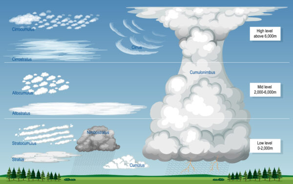
At sea, some clouds are unmistakable. Here are the ones to absolutely watch :
| Cloud type | Altitude | Description | Meaning | Recommended response |
|---|---|---|---|---|
| Cirrus | Very high (5-12 km) | White filaments, fibrous or hairy appearance. | Hot forehead approaching. If they thicken (cirrostratus), rain or wind within 24-48 hours. | Monitor the evolutionNo rush, but get the boat ready. |
| Cirro-stratus | Very high (5-12 km) | Transparent cloud cover, often with a halo around the sun or moon. | Hot forehead Nearby. Risk of light rain and moderate wind within 12-24 hours. | Check the forecast and reduce sail if necessary. |
| Altocumulus | Average (2-7 km) | Clouds in pebbles or rollers, often aligned. | Atmospheric instability. Risk of grain orthunderstorm within 6-12 hours. | Be prepared to scale back and watch the horizon. |
| Cumulus congestus | Low to medium | Large, budding clouds, dark base, significant vertical development. | Stage before the cumulonimbus. Risk of violent grain within 1-2 hours. | Reduce sail immediately and prepare the mooring lines. |
| Cumulonimbus | Very extensive (base at 500m, summit at 12-15km) | Cloudy Mountain with anvil-shaped summitBlack or very dark. | Immediate danger : thunderstorms, violent squalls, gusts >40 knots, hail, heavy rain. | Emergency : Reduce all sails, set sail for safety, wear vests and harnesses. |
| Nimbostratus | Low to medium | Thick, grey layer completely blocking out the sun. | Rain continues and moderate to strong winds. Risk of reduced visibility. | Navigate carefully, turn on the navigation lights. |



Other signs not to ignore
- Sudden change in wind direction : A wind that turns suddenly (e.g., a shift from southwest to northwest) may indicate a cold front or a grainIn the Mediterranean, the mistral or the tramontana often settle in after a Clear skies and a drop in pressure.
- Rapid drop in atmospheric pressure : A drop of 5 hPa or more in 3 hours is a sure sign degradation. Use a barometer (even digital) to follow this evolution.
- Sea forming rapidly : Of the short and chaotic waves (the “brittle” sea) indicate a near gale, even though the sky still seems clear.
- Temperature falling : A sudden drop temperature is often linked to the arrival of a cold front or a grain.
- Smells and sounds : A musty smell or a sudden silence (the birds fall silent, the wind drops) may precede a violent squall.
Differences between the Mediterranean and the Atlantic
| Criteria | Mediterranean | Atlantic |
|---|---|---|
| Grain type | Violent and localized grains, often linked to isolated thunderstorms or at mistral/tramontane. | Widespread gusts of wind, related to depressions or cold fronts. |
| Duration | Short (10 min to 1 hour) but intense. | Longer (several hours), with gusts and a rough sea. |
| Dominant clouds | Cumulonimbus (storms), altocumulus (grains). | Nimbostratus (continuous rain) cumulonimbus (grains). |
| Characteristic wind | Mistral (NW, violent, dry) Tramontane (NW), Sirocco (S, hot and humid). | West to northwest winds, often associated with Atlantic depressions. |
| Sea | Short and hollow sea (close waves). | Long and rough sea (Atlantic swell). |
| Season at risk | Spring and autumn (mistral/tramontane) summer (thermal storms). | Autumn and winter (depressions), summer (pre-frontal grains). |
How to react? Key steps before, during and after the grain
Before the grain: Anticipate and prepare
- Consult the forecast : Use the marine weather reports (Météo-France, Weather Consult, InfosWind) and the specialized weather apps (PredictWind, Windy).
- Monitor the barometer : A rapid decline should alert you.
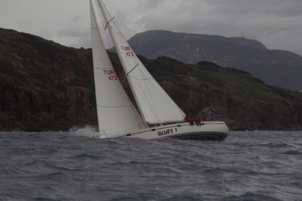
- Reduce sail : From the first signs (altocumulus, wind that shifts), Take in 1 or 2 reefs in the mainsail And roll up part of the sponge.
- Prepare the boat :
- Close the portholes and hatches to prevent leaks.
- Check the bilge pumps and the waterways.
- Take out the life jackets and the harness.
- Prepare the mooring lines and fenders if you are near a port.
- Crew briefing : Designate someone responsible one for sky surveillance and another for maneuvers.
During the grain: Maintain control
- Head for safety : If possible, flee from the grain by setting course towards a bay, port or sheltered area.
- Reduce the sail area as much as possible : Mainsail at 0, reduced genoa Or tormentin if the wind exceeds 25-30 knots.
- Hold the bar firmly : THE gusts can do deviate suddenly the boat. Avoid jibes (risk of capsizing).
- Stay attached : Wear vests and harnesses permanently.
- Avoid turning : THE short waves in the Mediterranean or the Atlantic swell can make the maneuver dangerous.
- Use the engine if necessary
After the grain: Check and resume navigation
- Take a safety check : Check the waterways, the state of sails and rigging, and the proper functioning of instruments.
- Spot the other boats Some may be in difficulty.
- Gradually resume operations : Wait for the wind to stabilize before setting sail again.
- Record observations : Time, cloud type, wind speed to improve your future forecasts.
Tools and resources for boaters
Official weather services
- Météo-France – Marine Weather : Coastal and offshore bulletinsWind maps, real-time alerts.
- Weather Consult : Detailed forecastGRIB files, alerts for boaters.
- InfosWind : Real-time wind 7-day forecast based on 150 anemometers along the French coastline.
- SHOM – Oceanographic Forecasts : Wind, wave and current maps for coastal and offshore navigation.
Mobile apps
- Marine Weather (Météo-France) : Free, official bulletins.
- PredictWind : High resolution modelsTools for regatta sailors.
- Windy : Intuitive visualization winds, waves and precipitation.
Conclusion: The key is observation and responsiveness
At sea, A squall or a gust of wind never appears without warning.. Knowing how to read clouds, monitor the wind and pressure, And act without delay make the difference between a serene navigation and one critical situation.
- In Mediterranean, be particularly vigilant to cumulonimbus and to sudden changes in wind (mistral, tramontane).
- On theAtlantic, anticipate depressions and the cold fronts, often accompanied by gusts and rough seas.
One last tip : Never underestimate the seaEven in clear weather, A grain of wheat can appear in 10 minutes. Stay alert, be prepared, and navigate carefully..